Started with protests in Daraa in 2011, the Syrian conflict rapidly turned into a war with a number of foreign powers supporting various militant groups (including al-Qaeda-linked) against the government of Bashar al-Assad. Since then, the country has been a point of instability in the Middle East.
Russia began a military intervention in Syria in 2015 after an official request by the Syrian government for military help against militant groups.This allowed the Syrian government to survive and to regain initiative in a battle against Hayat Tahrir al-Sham (formerly Jabhat al-Nusra, the Syrian branch of al-Qaeda), ISIS and other militant groups.
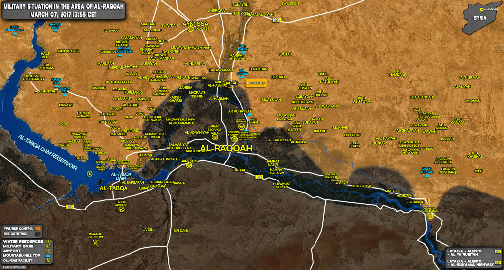
Interesting that SDF, no doubt with US Tacair and ground elements, have reached the choke point where the Euphrates narrows, the exact location I pinpointed seven weeks ago on my post to SF :
” I
have determined the target location as Lat : 35 42 28 N, Long : 39 50 25 E. On
GoogleEarth in degrees decimal this is 35.71 N, 39.84 E….(16JAN2017) I then commented on this US raid (recon in force) :
” US
have clammed up re mission purpose/objective/results, other than reporting no
friendly casualties, engagements or prisoners. Very suspicious. Was this a
pick-up, plant, salting of WMD (NBC) materiel ?? Is this to be
“discovered” as Assads hidden chem wpns stockpile to justify
insertion of US airborne units ? Or will US claim find of long-lost Iraqs WMD ?
Why mount a large heliborne (don’t know if CH47 or MH53 used ??) op in Indian
country, spend 90 mins on ground securing area including water plant, then
extract for no apparent reason ? …” Well we now know, on the SF map this “facilty “is now tagged as AL KIBAR MILITARY BASE. Does this confirm what we have suspected all along, that US/SDF forces will now effect a lodgement on the right bank thus blocking ISIS riverine and road travel up/down the N4 Raqqa-Deir Az-Zour ? Any bets that US airborne units now in theater will soon be “in country ” along the southern Euphrates ? Hmmm.
https://syrianfreepress.wordpress.com/2016/09/25/7-usa-bases-in-syria/
https://syria.liveuamap.com/en/2016/27-july-us-special-forces-build-up-base-in-lafarge-cement
Russian sat coverage could not have missed this from 2016.