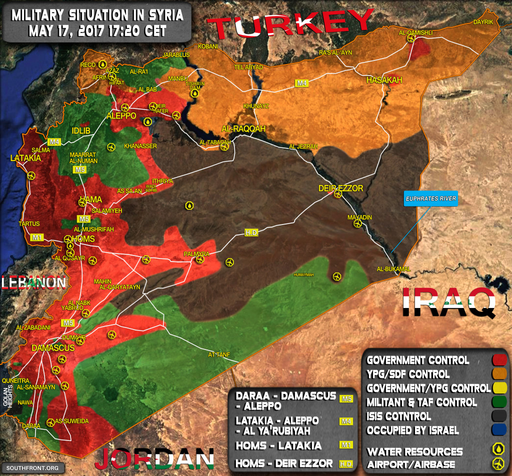
This map provides a general look at the military situation in Syria on May 17, 2017.
0 $
2,500 $
5,000 $
JANUARY 2026


North Hama/West Aleppo are cold? (with all the operation elsewhere is normal)
no mood to fight
Define “Cold”… SAA has made progress on both fronts, capturing a dozen villages in the process.
Earlier this week Tiger Forces were sent to the Aleppo-Ithriya highway as an additional support to the ongoing operations. From the Khanasser area they can choose to operate both to the East in N. Hama and to the West in W. Aleppo province.
I wonder how SAA in different parts of the country are able to communicate with each other over those long distances, if at all?
Those are not long distances. They will do just fine as long as US does not start bombing communication centers (both civil and military ones).
really? like from deir ezzor to damascus thats not a long distance? or the very northeastern part of syria to the very southwestern part like daraa?
Yep. For reference, imagine you are somwhere in Siberia or on a ship in the middle of Atlantic. I don’t want to get too technical in here, so let’s just say that radio waves can go really far.
The problem is that high power radio transmitters tend to attract attenition and get bombed. Using directional links and satellites helps with this.
do u know if they use cellphones too? it would be interesting to see a cellphone/network coverage map of syria these days
Military telecommunication infrastructure is independent from the civilian one, and that includes handheld radio sets (long before mobile phones became a thing). There is a nice photo of a field commander here https://southfront.org/detailed-analysis-of-battle-for-ramouseh-artillery-academy-in-western-aleppo-part-4/
Of course, in chaos of civil war you have to do with what you have, so I guess there were situations where cell phones were used for more than taking selfies and posting on twitter.
Cell phone coverage depends on state of infrastructure, so an estimate can be based on that. Red areas with no recent battles probably have good coverage, green and yellow ones not so much, and black ones are probably black in that way too.
Maybe with cell phones
Yea maybe. It would be interesting to see a map of cellphone coverage across Syria these days.
If anyone interested in look at what Idlib really looks like under Al Qeada control this Arab journalist secretly filmed there. It sure ‘aint what the State Department wants you to see…no ‘FSA’… just Al Qeada and Islamists;
https://twitter.com/jenanmoussa